Public rights of way
The Public Rights of way in Great Bromley are detailed below.
If you have any issues accessing these paths (if overgrown or other obstacles) please contact the Parish Clerk - see www.gbpc.org.uk. You can also use the Essex County Council "report it" tool here.
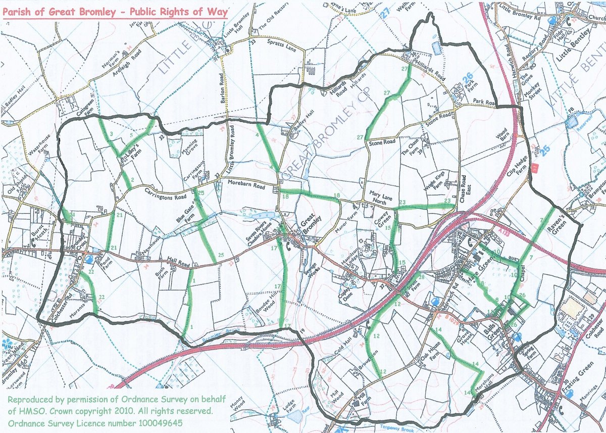
FP = footpath, BR = bridleway, BW = byway
- FP1: From road 200 yards south-east of Bush Farm in a south-westerly direction to the parish boundary with Elmstead where it continues.
- FP2: From the road south of Lilley's Farm in a southerly direction to Carringtons Road
- FP3: From the road north of Lilley's Farm in a northerly direction to the parish boundary with Little Bromley where it continues
- FP4: From the road south-west of Badley Hall in a north-easterly direction to the parish boundary with Little Bromley where it continues
- FP5: From the road north of Lilley's Farm in an easterly direction to the parish boundary with Little Bromley where it continues
- FP7: From the road north of Raven's Green at the parish boundary with Little Bentley in a westerly direction to its junction with Byway 10
- FP8: From Hare Green by 'Portlands' in a southerly direction to Chapel Lane
- BW1O: From Hare Green in a southerly then westerly direction to the road east of Methodist Chapel
- FP11: Known as 'The Alley'. From the B1029 at the south-eastern corner of the boundary of the property known as 1 & 2 Chapel Row, in a northerly direction then east to the junction with FP8
- FP12: From the B1029 in a westerly then south-westerly direction past Cold Hall to Elmstead Road east of 'The Hollies'
- FP14: From Elmstead Road 200 yards west of 'Courthouse Inn' PH, in a southerly and westerly direction to Morehams Hall at the parish boundary
- FP15: From Mary Lane North south-west of FP23 in a south-westerly direction to Back Lane West
- FP17: From Hall Road east of 'Seven Rivers' in a south-westerly direction to the parish boundary with Elmstead where it continues
- FP18: From Badley Hall Road, opposite 'Peace Cottages', in a south-easterly direction to Mary Lane North
- FP2O: From Hall Road north-east to St. George's Church
- FP21: From Hall Road, near Pond Farm, north-east to Carrinqtons Road east of Hazels Farm
- FP22: From Colchester Road west of 'Cross lnn' PH, south and south-west to the parish boundary with Elmstead where it continues
- FP23: From Mary Lane North at Cowey Green, in a south-easterly direction to Chase Road East south-west of Wright Kings Farm
- BR24: Known as Green Lane. From Briar Road, north-east to the parish boundary with Ardleigh where it continues
- FP25: From Hall Road north-west of 'Red House' in a general north-easterly direction via Blue Gate Farm to Carringtons Road
- FP26: Furze Lane. From the road near Union Place, east and then north to its junction with BYW10
- BR27: Cock Lane. From Stone Road north of The Chase, easterly to Hilliards Road north of Park Farm.
- FP28: From B1029, opposite FP12. in an easterly direction to Back Lane East